1936
Discovery by Alex Strickland, followed by 17 trenches and 10 diamond drill holes totaling 718.4 metres


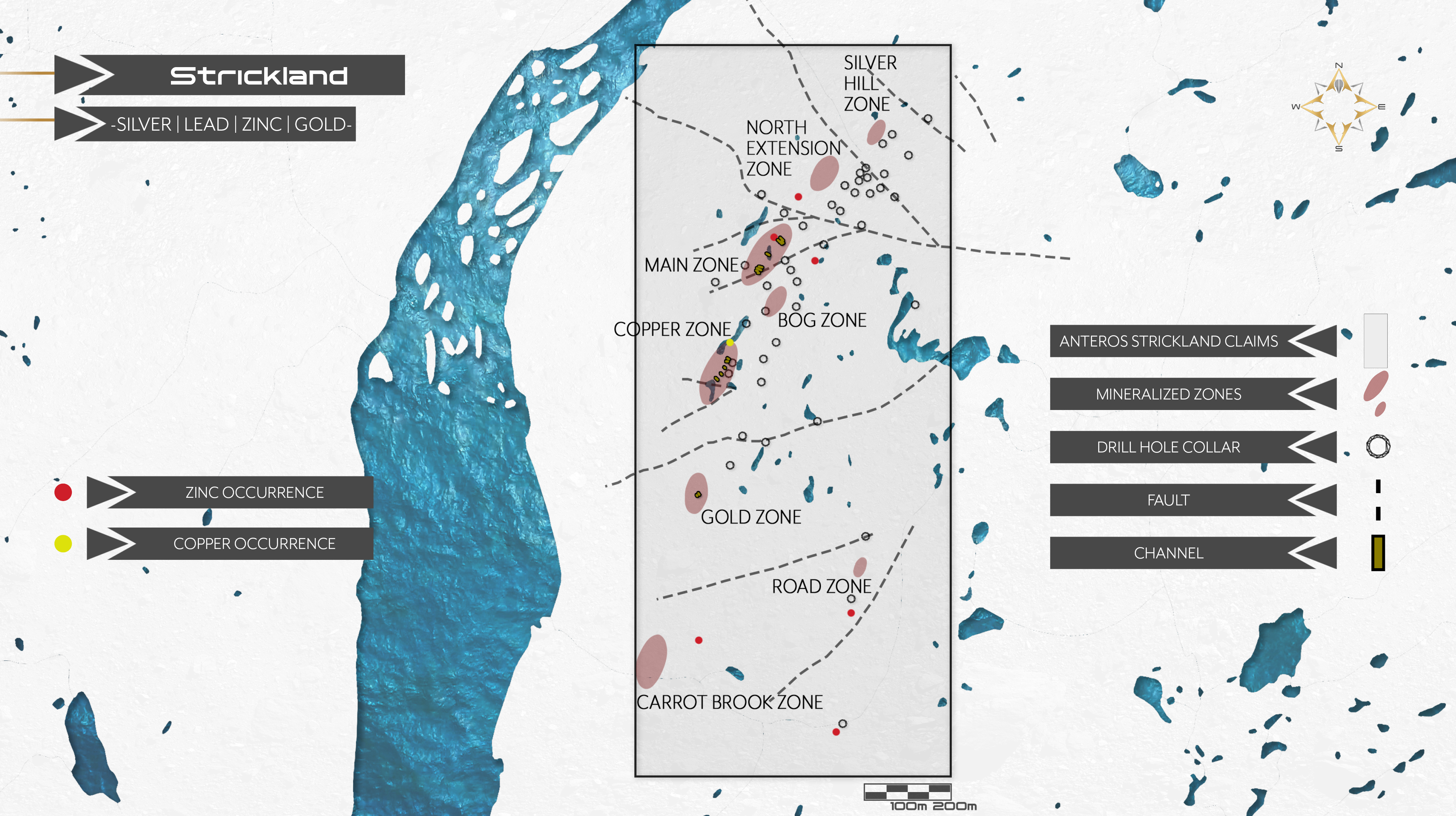


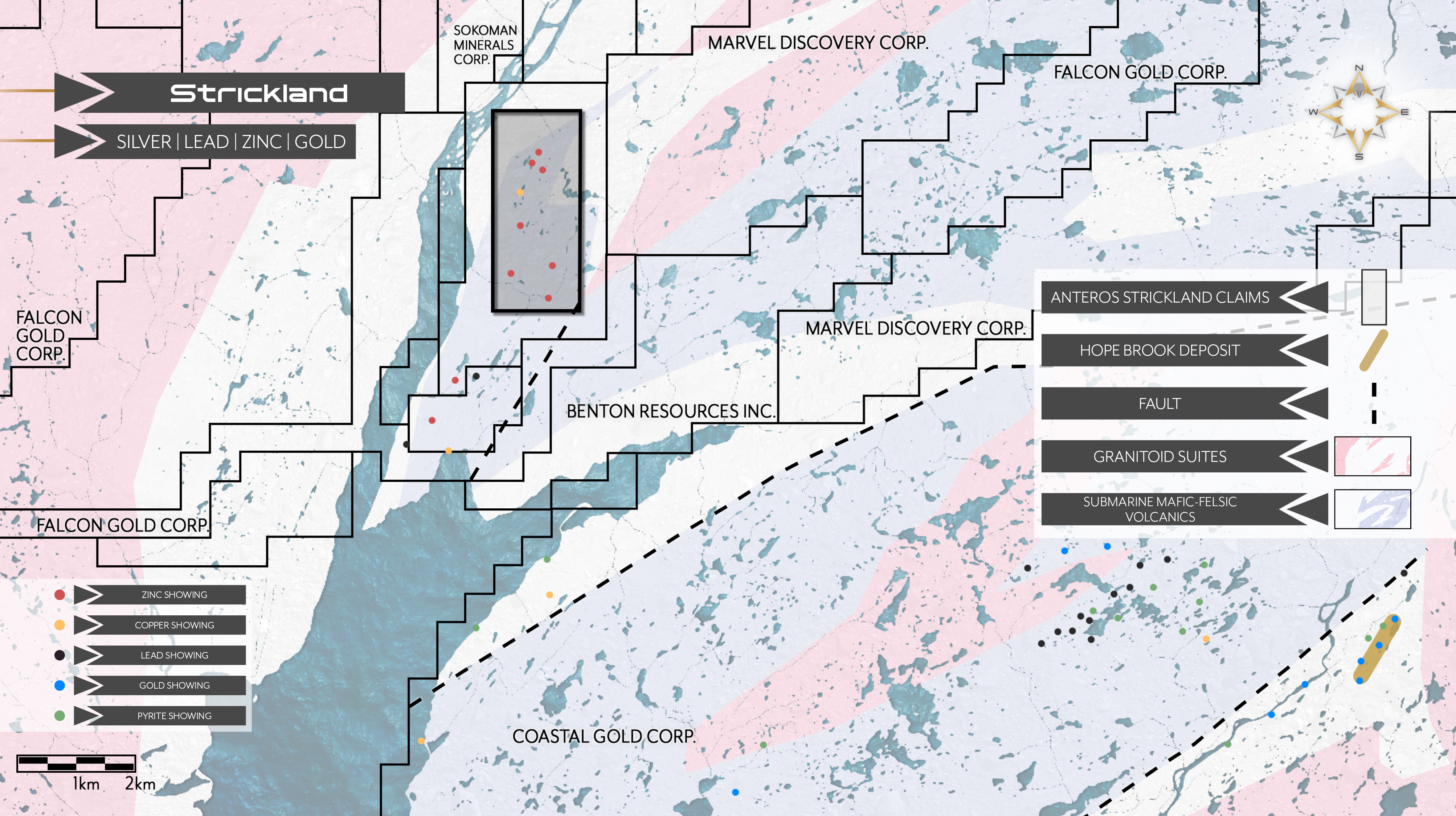
The Strickland Silver-Lead-Zinc (± Gold) Deposit is located in the La Poile Bay area of southwestern Newfoundland, Canada, 16 kilometres east of the Hope Brook Gold Deposit and historical mine. The Strickland Property is 5.25 kilometres-square and 100% owned by Anteros Metals Inc. The claims have undergone extensive exploration, giving rise to multiple mineralized zones within Newfoundland’s prolific gold district.
Central Newfoundland is comprised of the Ganderia Terrane, which is subdivided into the Gander Lake and Exploits Subzones by the Gander River Ultramafic Belt (GRUB) and associated parallel fault systems termed the JBP and Appleton Faults. Rocks of the Exploits (Dunnage) Zone consist of volcanic, volcaniclastic and sedimentary rocks of island-arc and back-arc affinity interpreted to represent remnants of the Iapetus Ocean. The Gander Zone consists of psammitic and semipelitic metasedimentary rocks from a continentally derived sedimentary wedge. Rocks of the Exploits Subzone were thrust onto the Gander Zone contemporaneous with the Taconian Orogeny.
The Strickland VMS Property overlies the Bay du Nord Group belt of rocks within the complex mélange of the Dunnage Zone. In the La Poile Bay region of south western Newfoundland, the Bay du Nord Group follows the sinuous trace of the Hermitage Flexure and is bounded to the north by the La Poile Intrusive Suite, and to the south by the Bay d’Est Fault and the Burgeo Granite.
The volcano-sedimentary sequences of the Bay du Nord Group consist of poly-deformed shale, siltstone, greywacke, conglomerate, and felsic volcaniclastics and flows, which have been reconstituted into a variety of schists within fault zones. The Strickland Main Zone occurs at a defined contact between mixed volcaniclastic and clastic sequences, and a sediment-dominated sequence and numerous other mineralized zones occur within 200 metres of this contact. The Baggs Hill Granite, exposed approximately 1.2 kilometres northeast of the Main Zone, may have acted as a heat source to circulate the hydrothermal fluids which deposited the metals.
Metals of the Property were deposited from the neutralization of acidic, metal-bearing, briney solutions emanating from a hydrothermal conduit. Some textures on the property suggest reworking or transportation of the sediments shortly after deposition. At the Main Zone, chemical reactions of the footwall rocks with metal bearing brines may have produced intense sericitization and silicification. The combined strike length of all seven known zones of the Strickland Property is 1.4 kilometres.
The Strickland Property also shows excellent potential for epithermal gold mineralization based on comparison with the nearby Hope Brook area. The Hope Brook gold deposit was discovered in 1983 by Selco Divison of BP Resources Canada Ltd. Ore reserves at the Hope Brook were recorded as 11.2 million metric tonnes at 4.54g/t Au, at a cut-off grade of 2.5g/t Au (Mackenzie, 1986).
1936
Discovery by Alex Strickland, followed by 17 trenches and 10 diamond drill holes totaling 718.4 metres
1965
Kopan Developments Ltd. drills 10 diamond drill holes totaling 1,035 metres
1967
O’Brien Gold Mines Ltd. commissions airborne magnetic surveying
1968
Long Lac Mineral Exploration Ltd. conducts a ground VLF survey over the Property, supporting EM anomalies coincident with mineralized zones and conducts diamond drilling totaling 1,215 metres
1970
Noranda Exploration Co. undertakes stream sediment sampling and geological mapping
1977-1980
Falconbridge Nickel Mines Inc. (“Falconbridge”) conducts geological mapping, geophysical and geochemical studies, and drills 43 diamond drill holes totaling 4,713 metres
1981
Falconbridge defines an unclassified mineral inventory (Prince, 1981)
2005-2009
Quinlan performs prospecting, mapping, and sampling of historical drill core, confirming epithermal gold potential
Discovery by Alex Strickland, followed by 17 trenches and 10 diamond drill holes totaling 718.4 metres
Kopan Developments Ltd. drills 10 diamond drill holes totaling 1,035 metres
O’Brien Gold Mines Ltd. commissions airborne magnetic surveying
Long Lac Mineral Exploration Ltd. conducts a ground VLF survey over the Property, supporting EM anomalies coincident with mineralized zones and conducts diamond drilling totaling 1,215 metres
Noranda Exploration Co. undertakes stream sediment sampling and geological mapping
Falconbridge Nickel Mines Inc. (“Falconbridge”) conducts geological mapping, geophysical and geochemical studies, and drills 43 diamond drill holes totaling 4,713 metres
Falconbridge defines an unclassified mineral inventory of 260,000 tonnes of 195g/t Ag and 5.25% Pb/Zn at the Main Zone; 15,000 tonnes of 480g/t Ag and 2% Pb/Zn at the Silver Hill Zone; and 750,000 tonnes of 2% Pb/An (Main Zone North Extension (Prince, 1981)*